Story

Surveying Texas’s Post-Hurricane Harvey Landscape, with a Camera and a Four-Seat Plane

Hurricane Harvey is expected to be the costliest natural disaster in U.S. history. Thousands of homes were flooded, many requiring major repairs. Here debris piles await removal from gutting two homes in Northwest Forest, a subdivisions of Beaumont. Image by Dan Grossman. United States, 2017. 

Hurricane Harvey is expected to be the costliest natural disaster in U.S. history. Thousands of homes were flooded, many requiring major repairs. Here debris piles await removal from gutting two homes in Northwest Forest, a subdivisions of Beaumont. Image by Dan Grossman. United States, 2017. 

The aerial photographer Alex MacLean began flying in the early nineteen-seventies, while studying architecture and urban planning at Harvard’s Graduate School of Design. He realized that with a relatively inexpensive 35-mm. camera and a plane he could demonstrate spatial relations between downtowns and suburbs, between transportation networks and housing, between built and open space. Later, when he began his career as a photographer, he used his aerial perch to showcase otherwise unseen worlds, such as rooftop gardens and spas, and military-aircraft junkyards. He photographed patterns, such as farmland tillage lines, shipping containers stacked in tiers, and geometrically arranged beach umbrellas. Many of his photos—some more subtly than others—are made out of environmental concern. A series he shot in 2014 drives home the awesome scale of tar-sands strip mines in Alberta, Canada. An ongoing project documents no-till farming, a practice that reduces soil loss and slows global warming.

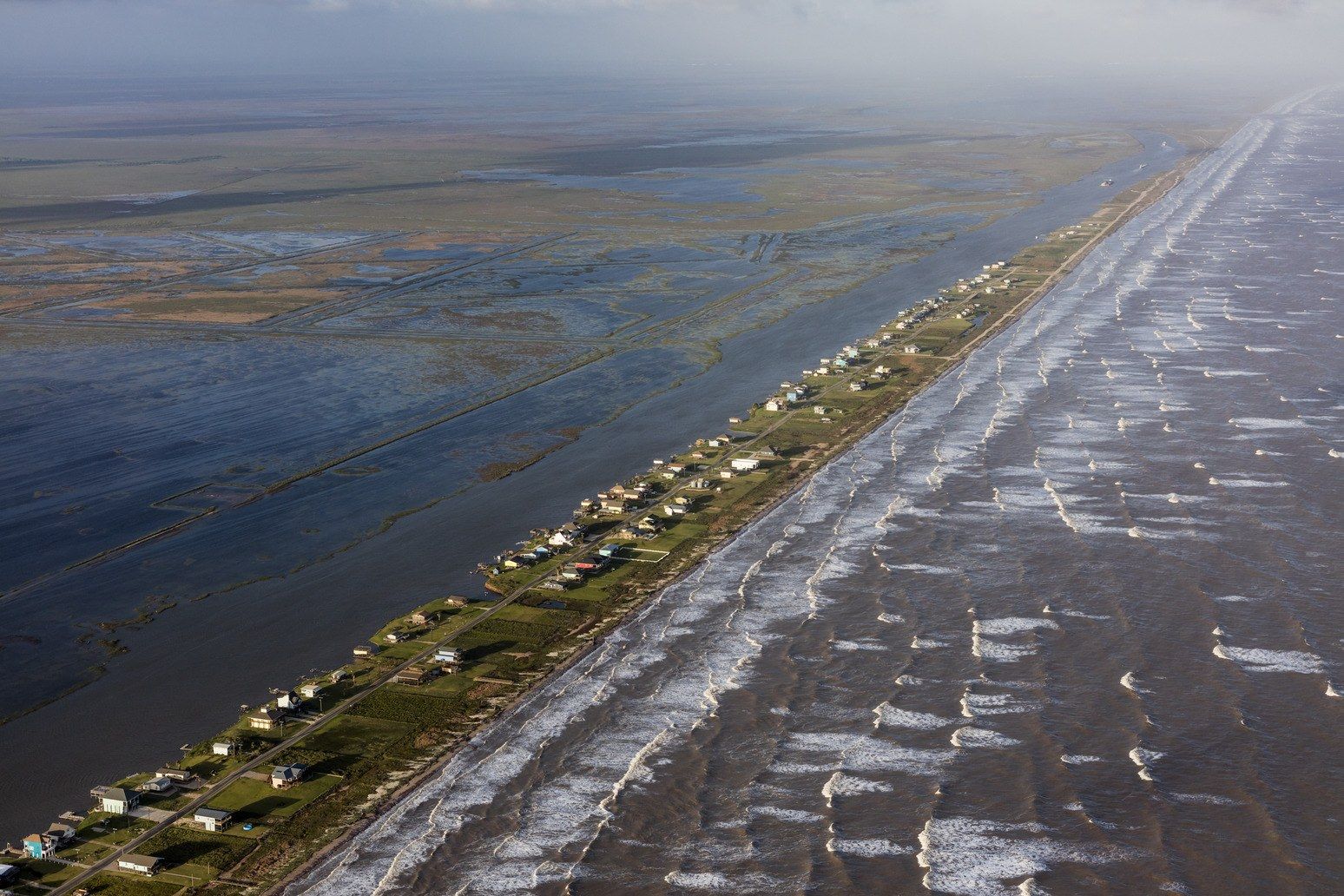
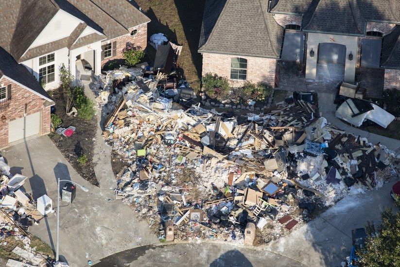
Last month, with funding from the Pulitzer Center on Crisis Reporting, MacLean and I rented a Cessna 172 four-seat airplane in Nashville, where a pilot he knows gave us a good deal. MacLean flew us from there to southeast Texas. A month had passed since Hurricane Harvey had made landfall. The aftermath of the storm—expected to be the costliest natural disaster in U.S. history—had been photographed exhaustively, with images of residents canoeing down flooded streets and sorting through the wreckage of their water-logged homes. Alex wanted something different: by photographing the region from above, he wanted to capture what had made Texas so vulnerable, and why disaster planners, in preparing for future storms, can’t ignore the changes that climate scientists say global warming is bringing.

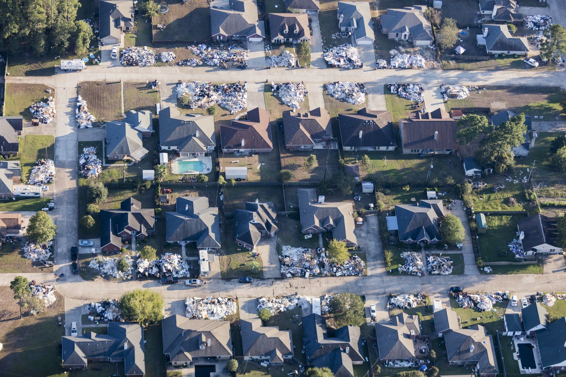
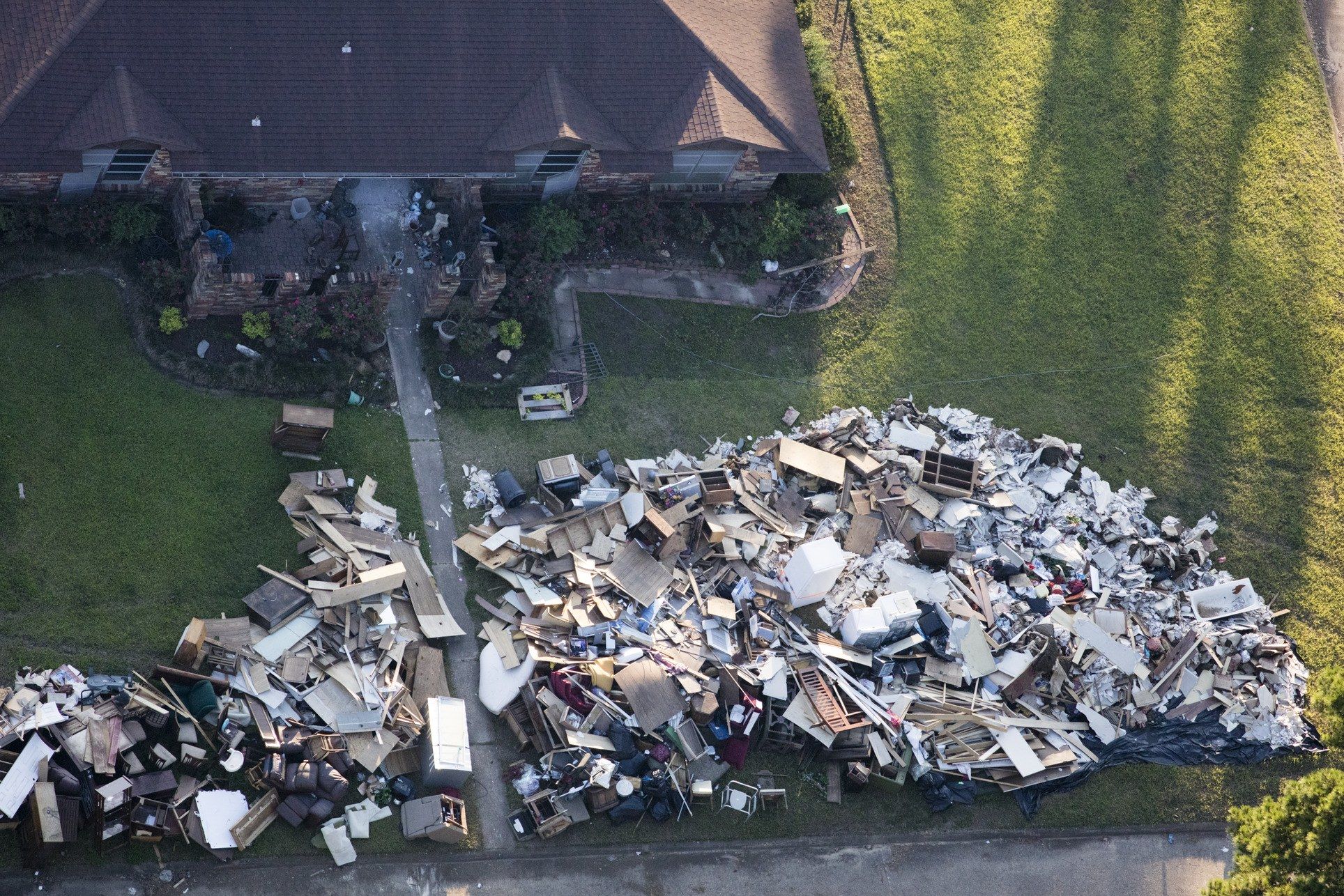
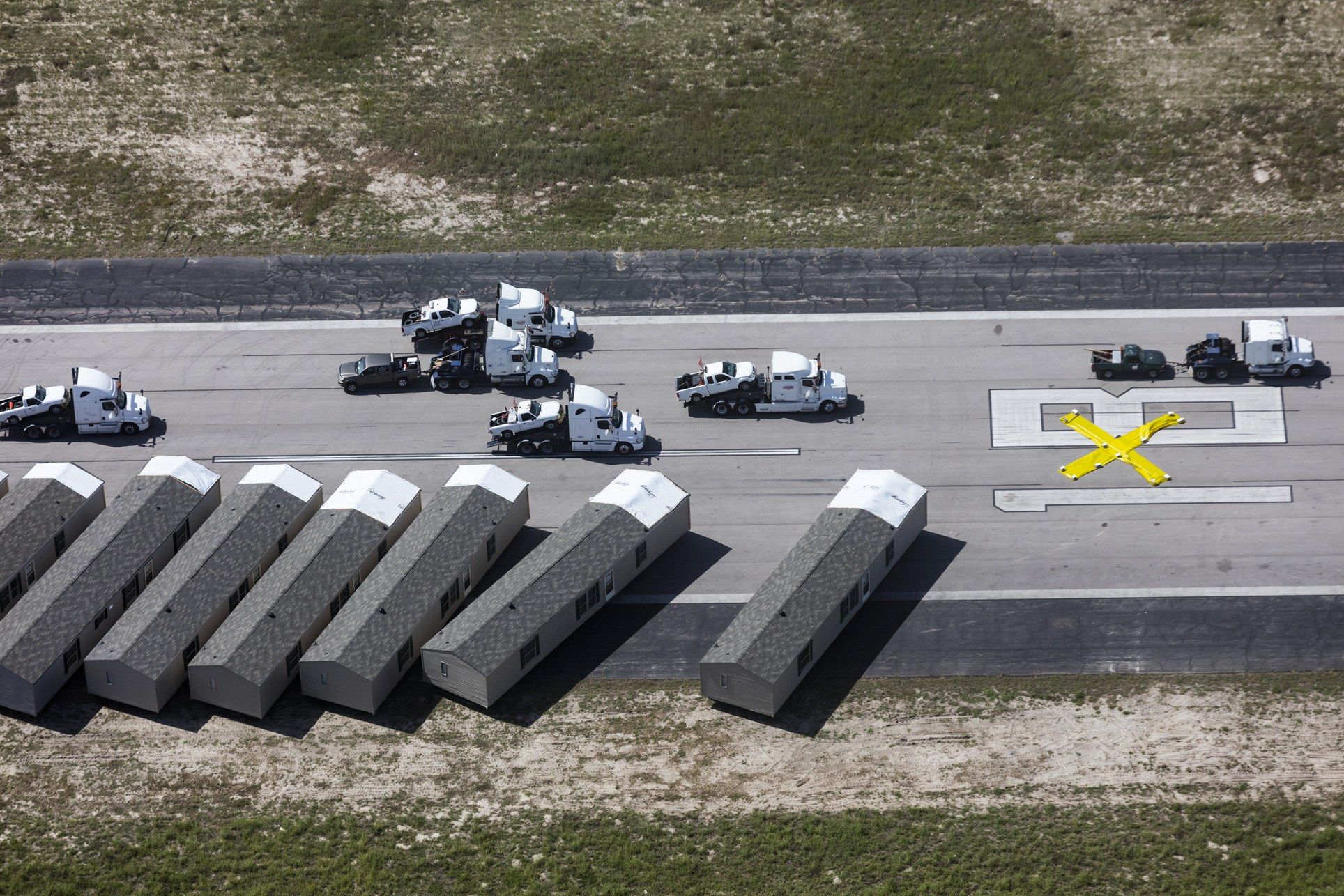
Our first stop was Beaumont, on the Gulf Coast. The crew at the airport there suggested that we fly over the nearby city of Vidor, where piles of debris still lined entire residential blocks, awaiting removal by contractors. We passed above a rising mountain of debris west of Beaumont, where trucks were delivering materials they’d carted away from the insides of houses in the nearby suburbs of Bevil Oaks and Northwest Forest. Nearly every house there required gutting.

During times of extreme rain, such as Hurricane Harvey, Houston’s Barker Reservoir (or, as part of it is called on the west side of the city, George Bush Park) impounds water from the larger river called Buffalo Bayou, in order to prevent flooding downstream. Image by Alex MacLean. United States, 2017.

During times of extreme rain, such as Hurricane Harvey, Houston’s Barker Reservoir (or, as part of it is called on the west side of the city, George Bush Park) impounds water from the larger river called Buffalo Bayou, in order to prevent flooding downstream. Image by Alex MacLean. United States, 2017.

At a temporary dump north of Beaumont, containing nearly a hundred thousand cubic yards of furniture and demolition waste from the suburbs of Bevil Oaks and Northwest Forst, crushed water-damaged drywall gleams white. Image by Alex MacLean. United States, 2017.

At a temporary dump north of Beaumont, containing nearly a hundred thousand cubic yards of furniture and demolition waste from the suburbs of Bevil Oaks and Northwest Forst, crushed water-damaged drywall gleams white. Image by Alex MacLean. United States, 2017.

Storm water flowing south from Houston overflowed the banks of the Brazos River, sweeping away trees and earth, and flooding low-lying neighborhoods. Image by Alex MacLean. United States, 2017.

Storm water flowing south from Houston overflowed the banks of the Brazos River, sweeping away trees and earth, and flooding low-lying neighborhoods. Image by Alex MacLean. United States, 2017. 

When Harvey made landfall in Rockport, Texas, powerful tornadoes appeared, ripping apart and overturning mobile homes. Image by Alex MacLean. United States, 2017.

When Harvey made landfall in Rockport, Texas, powerful tornadoes appeared, ripping apart and overturning mobile homes. Image by Alex MacLean. United States, 2017. 

A real-estate agent from Vidor says that, in the wake of the hurricane, the neighborhood of the Wexford Park was "a complete loss. Not one home came out of it." Image by Alex MacLean. United States, 2017.

A real-estate agent from Vidor says that, in the wake of the hurricane, the neighborhood of the Wexford Park was "a complete loss. Not one home came out of it." Image by Alex MacLean. United States, 2017.

The real-estate agent from Video says that reconstruction in the town is hampered by a lack of places where contractors can stay, and that many residents are "sleeping in the tents in their front yards." Image by Alex MacLean. United States, 2017.

The real-estate agent from Video says that reconstruction in the town is hampered by a lack of places where contractors can stay, and that many residents are "sleeping in the tents in their front yards." Image by Alex MacLean. United States, 2017. 

Administrators of the Royal Purple Raceway, in Baytown, Texas, have cancelled its fall schedule and turned the four-hundred-acre property into a temporary lot for about twenty-eight thousand storm-damaged vehicles that await salvage or disposal. Image by Alex MacLean. United States, 2017.

Administrators of the Royal Purple Raceway, in Baytown, Texas, have cancelled its fall schedule and turned the four-hundred-acre property into a temporary lot for about twenty-eight thousand storm-damaged vehicles that await salvage or disposal. Image by Alex MacLean. United States, 2017. 

After Hurricane Harvey struck, the north-south runaway at Rockport's Aransas County Airport was converted into a staging area for recovery efforts, first as a lot for utility trucks and then for mobile homes brought in by FEMA to temporarily replace destroyed buildings. Image by Alex MacLean. United States, 2017.

After Hurricane Harvey struck, the north-south runaway at Rockport's Aransas County Airport was converted into a staging area for recovery efforts, first as a lot for utility trucks and then for mobile homes brought in by FEMA to temporarily replace destroyed buildings. Image by Alex MacLean. United States, 2017. 

In Key Allegro, a coastal town where Harvey made landfall, the devastation was made worse by the fact that, prior to February, 2016, the lack of a designated flood zone allowed for homes to be constructed as close to the water as owners desired. Alex MacLean. United States, 2017.

In Key Allegro, a coastal town where Harvey made landfall, the devastation was made worse by the fact that, prior to February, 2016, the lack of a designated flood zone allowed for homes to be constructed as close to the water as owners desired. Alex MacLean. United States, 2017. 

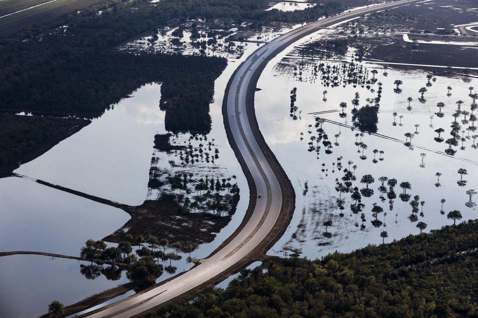
We flew low over Barker Reservoir on our approach to West Houston Airport. Pools of water still glistened in the normally dry basin. Barker was designed to retain storm water, protecting Houston from flooding. During Harvey, it didn’t work as expected. Too much water flowed into the basin, flooding subdivisions on the area’s periphery. Then, fearing that levees might be breached, water managers sought to prevent even more disastrous flooding by opening Barker’s spillway gates, inundating already sodden neighborhoods downstream.

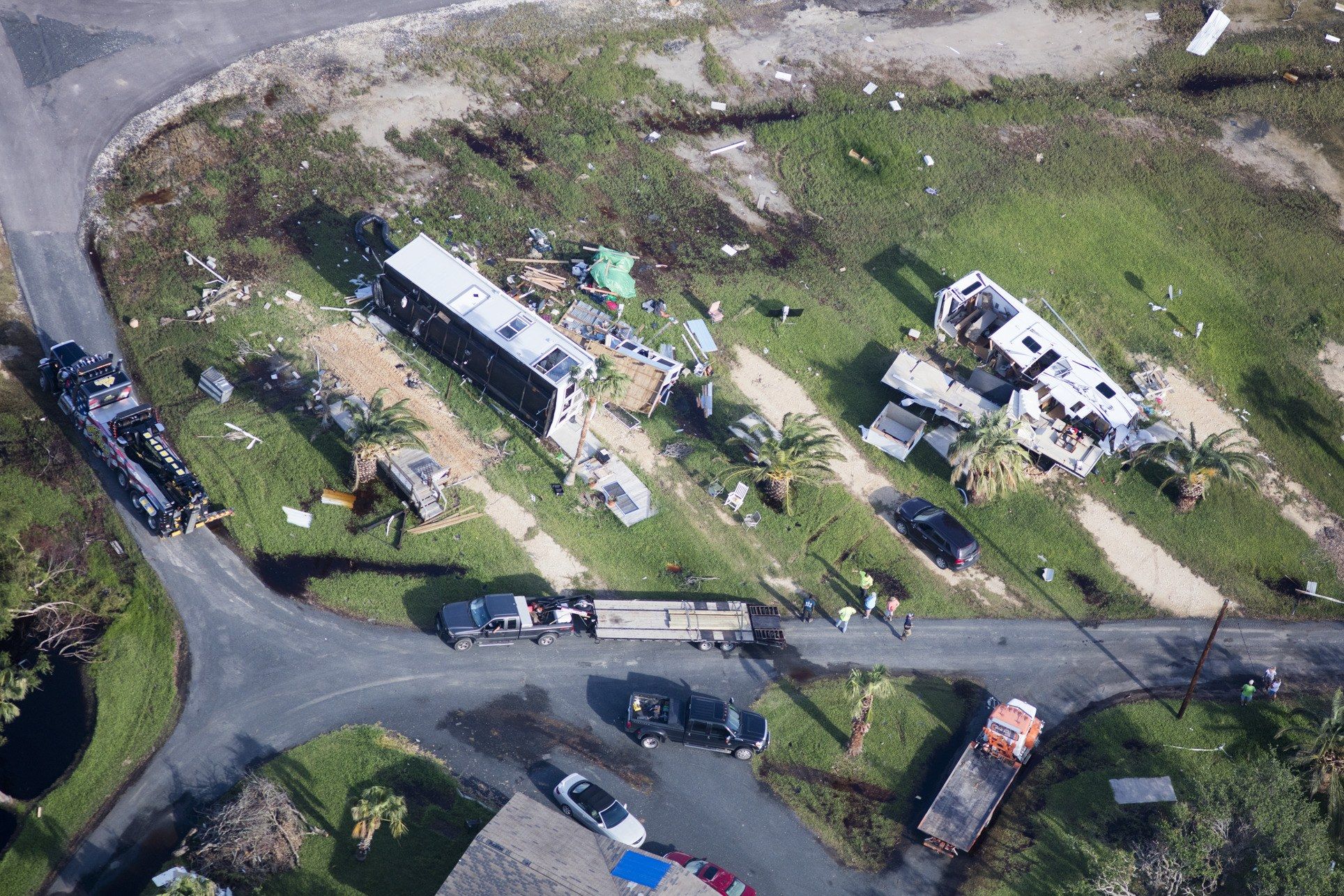
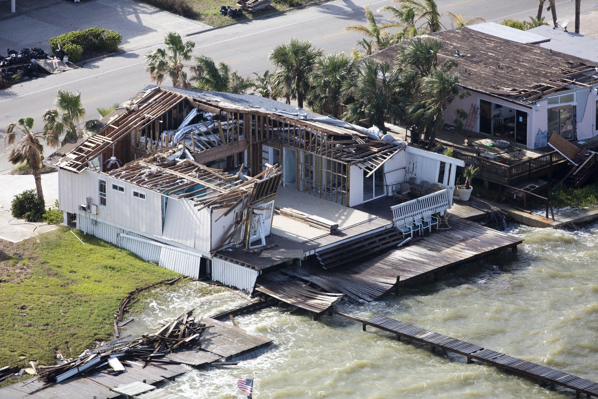
After Houston, Alex flew on without me to Rockport, where Harvey first made landfall. Wind, not water, had caused most of the damage there. A-hundred-and-thirty-mile-per-hour winds and swarms of tornadoes had ripped roofs off buildings and knocked over mobile homes. Alex saw worrisome signs for the future of development on the Gulf Coast. By chance, he’d arrived at high tide—and at an unusually high one. In the wealthy neighborhood of Key Allegro, seawater was lapping near the doors of the expensive homes.

In Bay City, located between the Gulf of Mexico and the Intercoastal Waterway, building codes require new homes to be built thirteen feet above mean sea level—but that rule won’t prevent damage from a direct hit by a storm and, with sea level rise, will become less effective every year. Image by Alex MacLean. Unites States, 2017.

In Bay City, located between the Gulf of Mexico and the Intercoastal Waterway, building codes require new homes to be built thirteen feet above mean sea level—but that rule won’t prevent damage from a direct hit by a storm and, with sea level rise, will become less effective every year. Image by Alex MacLean. Unites States, 2017.