Story

Brazil: Mapping People in the Amazon

The Saude e Alegria team reached sleepy and peaceful Boim, located more than one and a half hours away by boat from the nearest town of Santarem. Image by Rema Nagarajan. Brazil, 2012.

Boim is a community of 130 families on the banks of the Tapajos River. A meeting of people from several other communities was arranged here for the community mapping exercise. Image by Rema Nagarajan. Brazil, 2012.

The local cultural center where the community mapping takes place. Image by Rema Nagarajan. Brazil, 2012.

The cultural center is also a telecenter, part of a project to connect these far-flung communities to each other and to the rest of the world through internet and radio. Image by Rema Nagarajan. Brazil, 2012.

The area where the micro-mapping of communities is being done is within the red rectangle. Image by Rema Nagarajan. Brazil, 2012.

Magnolio Oliveira, head of the communication division of Saude e Alegria, explaining the process of community mapping and its importance. Image by Rema Nagarajan. Brazil, 2012.

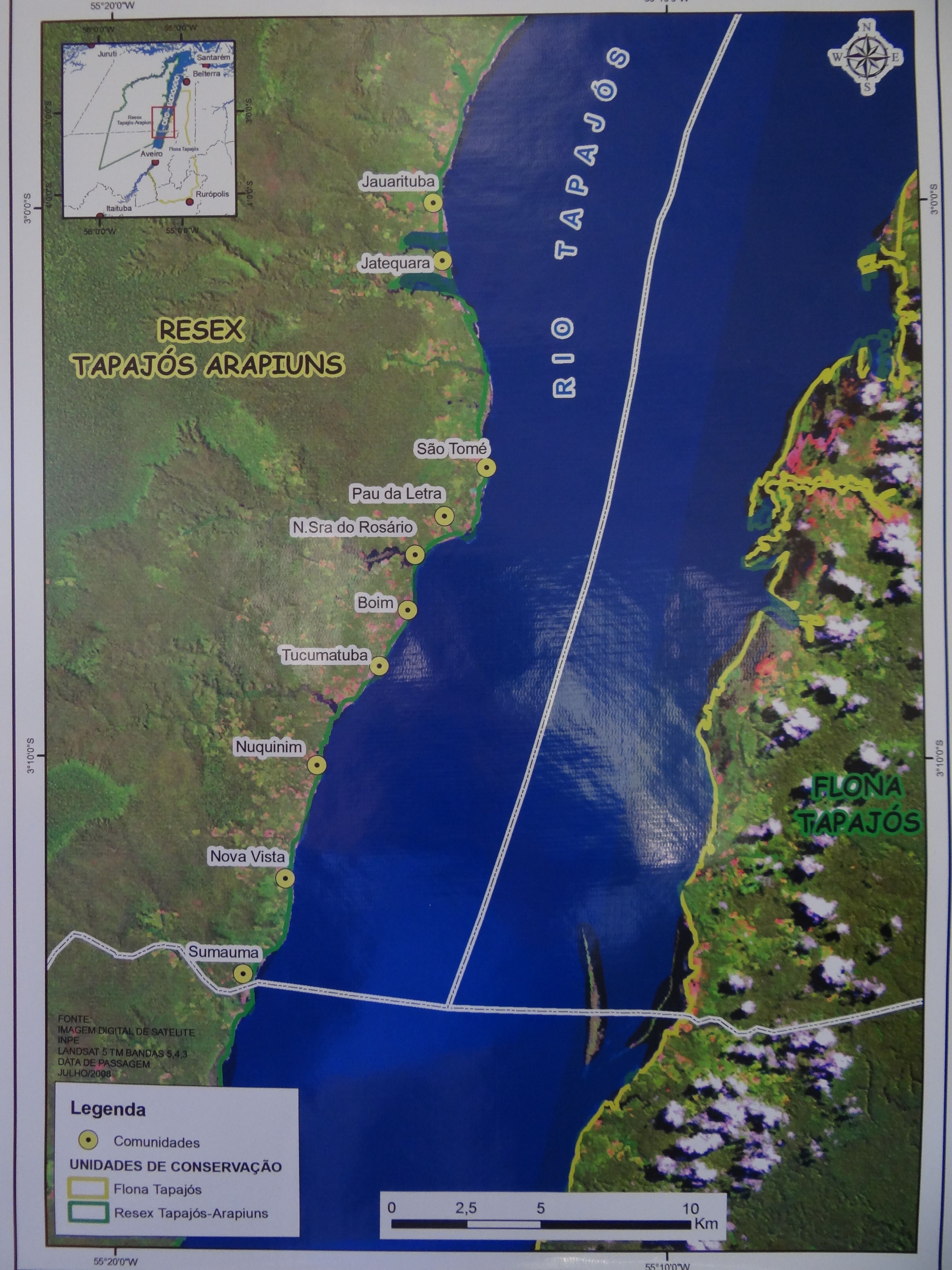
The ten communities of "ribinheiros," or riverside people, living in the Tapajos Arapuins reserve along the Tapajos River. Image by Rema Nagarajan. Brazil, 2012.

Magnolio Oliviera gives a demonstration of community mapping and explains how water sources, schools, health posts and orchards or plantations have to be marked on the maps. Image by Rema Nagarajan. Brazil, 2012.

Everyone gets busy with the drawing of the maps. Some use freehand while others use the scale to get perfectly straight lines. Image by Rema Nagarajan. Brazil, 2012.

A lot of erasing and redrawing as everyone tries to make an accurate representation of their community. Image by Rema Nagarajan. Brazil, 2012.

Exchanging ideas on how to improve the mapping of the resources and amenities in their communities. Image by Rema Nagarajan. Brazil, 2012.

The cyber cell inside the community center has wireless internet and laptops, which the community can use. Image by Rema Nagarajan. Brazil, 2012.

Youngsters online in the cyber cell. Image by Rema Nagarajan. Brazil, 2012.

Internet is a huge draw. Almost all the young people have Facebook and e-mail accounts. Image by Rema Nagarajan. Brazil, 2012.

Clarifying doubts about how to use the mobile phones distributed to local residents to take photos and shoot short videos of their lives. Image by Rema Nagarajan. Brazil, 2012.

One by one the maps start taking shape. Image by Rema Nagarajan. Brazil, 2012.

A detailed map showing the location of the school, church, the football ground, the water tank, the community radio center and telephone booth in Jauarituba. Image by Rema Nagarajan. Brazil, 2012.

The names of the people from the community who drew the map. Putting their names to their work inculcates a sense of pride. Image by Rema Nagarajan. Brazil, 2012.

The village square of Boim, which found a place on the map. Image by Rema Nagarajan. Brazil, 2012.

The health post of Boim was also geocoded. Image by Rema Nagarajan. Brazil, 2012.

A post-mapping discussion. Image by Rema Nagarajan. Brazil, 2012.

The result of the mapping exercise is a series of monographs about each community with photographs, detailed maps, history and a record of amenities and resources. Image by Rema Nagarajan. Brazil, 2012.

Macro level territorial mapping of the Tapajos-Arapiuns extractive reserve area (an area in which the residents of the forests are allowed to extract forest products, but the forest itself is protected) showed that 72 communities of 4,500 families or almost 20,000 people live within the reserve's 640,000 hectare area. That is how far-flung the communities are in the Amazon region, although most of them can be found in villages along the river, which is the highway for the region since you cannot cut roads through the forest.

Saude e Alegria (Health and Happiness), an NGO that works on issues of health, environment and sustainable development in the Tapajos area, is now doing micro-mapping or community mapping to improve land planning and to give the communities the tools needed to plan their own development. This micro-mapping, which was started last year, is expected to cover ten communities along the banks of the Tapajos River located in the reserve area. The project will be completed by the end of the year, after which it could be repeated in other territories depending on the availability of funds.

“We hope that the government will be able to take this model and replicate it. It is important to map the communities to understand their needs and to acknowledge their existence. Amazon is not just a vast empty forest. It has people living in it, dependent on it. No plan to protect and preserve the Amazon can be successful without acknowledging and addressing the needs of the people there,” says Caetano Scannavino, project coordinator in Saude e Alegria.